
The Odisha government has asked all the district collectors to remain prepared for any eventuality, and directed the administration to evacuate people from low-lying areas in the event of heavy rain.

Kerala has been receiving rainfall since Saturday and 10 out of the 14 weather monitoring stations in the state have received more than 2.5 mm rains.

"The season averaged maximum temperatures in Himachal Pradesh, West Rajasthan, Konkan, Goa, Coastal Karnataka, Kerala and Arunachal Pradesh are likely to be higher than normal by 0.5-1.0 degree Celsius," the Met department has said in its forecast.

While weather forecasters remain divided on how the monsoons will play out in India over the next few months, analysts believe the news at the current juncture - at best - can trigger a knee-jerk reaction in the markets. They believe it is too early to say whether the sub-par monsoon on account of El Nino can seriously dent the market sentiment in the short-to-medium term. "These are just initial forecasts and we will have another round / status update from the weather forecasters a month down the line.

Monsoon in August was almost 24 per cent below normal, which was the sixth driest August since 1901. It came on the back of a 7-per cent monsoon shortfall in July.

Monsoon is likely to reach Maharashtra and Goa in the next two days, the India Meteorological Department said on Monday, with a private weather forecasting agency predicting sustained heavy rains later this week.

The rains after arriving over Kerala will quickly cover Tamil Nadu and Karnataka, but then might slacken a bit, which could delay its arrival over Northwest India.

However, it's too soon to see any trend; July rain is key.

The mercury breached the 46-degree Celsius mark in several places such as Allahabad (46.8 degrees Celsius) and Jhansi (46.2 degrees Celsius) in Uttar Pradesh; Sports Complex (46.4 degrees Celsius) in Delhi; Ganganagar (46.4 degrees Celsius) in Rajasthan; Nowgong (46.2 degrees Celsius) in Madhya Pradesh; and Maharashtra's Chandrapur (46.4 degrees Celsius).

https://www.rediff.com/business/report/quality-control-orders-what-does-this-mean-for-domestic-industry/20240425.htm

LIVE! Incessant rains: Red Alert in 5 Kerala districts

The health minister said the Centre has taken timely measures ahead of the summer season to address heatwave-related illnesses.

The searing heat pushed the city's peak power demand to its highest for May, while the Delhi government directed the schools that have not closed for summer vacations to do so with immediate effect.

Total area impacted across India pegged at 18.9 mn hectares.

The IMD came out with a dismaying prediction.

The exercise, Agriculture Minister Radha Mohan Singh said, will help ease any possible impact of sub-par rainfall on farmers.

The weather bureau has issued a red alert for neighbouring Raigad and Palghar districts predicting heavy to very rainfall at a few places and extremely heavy rain at isolated places for Wednesday. An orange alert is sounded for Thane district.

We had prepared a contingency plan for 580 districts, the minister said.

Gross Value Added (GVA) growth in agriculture and allied activities in the first quarter of the 2024-25 financial year (Q1FY25) dipped to 2.7 per cent at constant prices from 4.2 per cent in Q1FY24 due to a drop in output of some crops following heatwave in the main growing months. Low post-monsoon rains, which dried most of the reservoirs in several states across the country, also impacted the production of many crops. At current prices, the growth was estimated at 8.5 per cent as against 4.1 per cent in Q1FY24 due to a spike in food inflation during the April to June months of FY25.

The IMD director said, the cyclonic storm Tauktae in the Arabian sea is moving away from the Kerala coast and is now approaching the Karnataka coast.

Rain or thundershowers have also been predicted in south interior Karnataka and at a few places over Coastal Karnataka and North interior Karnataka.

The city's 24-hour Air Quality Index, recorded at 4 pm every day, stood at 418, up from 334 the previous day, and it may trigger stringent restrictions under the third stage of the graded response action plan to mitigate hazardous conditions.

Widespread rains lashed parts of Tamil Nadu on Thursday, prompting authorities to declare a holiday for schools in Chennai and many other districts.
With different agencies showing divergent predictions regarding the southwest monsoon, the central government and states are gearing up to face adversity with various line ministries reportedly being directed to undertake mock drills and hold preparatory meetings. Around 56 per cent of the net cultivable area of the country is rain-fed, accounting for 44 per cent of foodgrain production. The June-September rains contribute around 73 per cent of the annual precipitation.

The rains have so far been four per cent below normal.
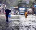
Some low-lying places like Hindmata, and areas in Dadar and Sion, including the Gandhi Market and road number 24 in Sion, were inundated, forcing pedestrians to wade through the water and making it difficult for motorists to commute.

For the second successive year, Monsoon is likely to be below normal with parts of north-west and central India to be the most affected.

The India meteorological department said another western disturbance is likely to bring storms and rain to the northern plains, including Delhi, over the next few days.

Mumbai and certain adjoining areas experienced pre-monsoon showers, sources said on Sunday.

The deep depression over central Bay of Bengal is likely to intensify into a cyclonic storm by Sunday evening and after changing course in a northeastward direction from northwest.

Heavy rains, coupled with thunderstorm, lashed Mumbai on Tuesday evening, bringing the soaring temperatures down and giving respite to the citizens from the sweltering heat.

With the cooling down of heatwaves as the monsoon spreads across the country, power demand has fallen by 12.5 per cent from the start of this month till Monday. Peak power demand of the country had touched a record of 210 Gw last week, mostly due to rising temperatures and opening up of the economy. Compared with the beginning of this month, almost all states have seen a fall in power demand. Punjab, however, is an exception where the power demand on Monday was 17 per cent higher than on June 1.
Agriculture activity, according to recent channel checks by Prabhudas Lilladher, is expected to continue at a strong pace in FY22.

Normally, monsoon reaches Delhi by June 27. It covers the entire country by July 8. Last year, the wind system had reached Delhi on June 25 and covered the entire country by June 29.

The IMD defines a normal monsoon as one which delivers between 96 and 104 per cent of the 50-year average rainfall for the season.

A minister said the country had 7% less rain than normal.

The orange alert implies that authorities should be ready to handle situations arising out of severe weather.

Above-normal heatwave days are predicted in most parts of central, east and northwest India during this period.

The India Meteorological Department said the southwest monsoon further advanced into Delhi, Uttar Pradesh, Himachal Pradesh, Jammu and Kashmiri, some parts of Punjab, Haryana and Rajasthan on June 30.